From January 29-31, 2025, the ISPRS, EARSeL & DGPF Joint Istanbul Workshop on Topographic Mapping from Space brought together experts in remote sensing, geospatial analysis, and Earth Observation (EO) technologies to discuss the latest advancements in satellite-based mapping. The event, held at Yıldız Technical University’s Davutpaşa Congress Centre, was dedicated to Dr. Karsten Jacobsen’s 80th birthday, celebrating his contributions to the field.
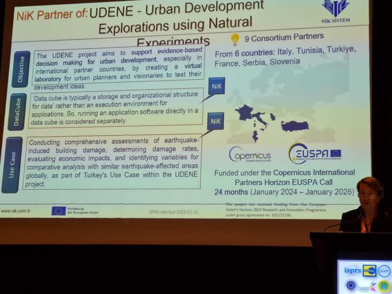
As part of the event, NiK System presented UDENE’s innovative approach to evidence-based urban development, highlighting how the project leverages vast amounts of Copernicus Earth Observation data to support urban planners and decision-makers. Through a dedicated presentation, attendees were introduced to UDENE’s core objectives, the Data Cube technology, and the project’s Use Case in Turkey, which focuses on assessing earthquake-induced building damage and economic impacts.
With the workshop’s emphasis on topographic mapping and spatial data, UDENE’s presence was particularly relevant. The project’s methodology—using multi-dimensional models of urban areas to explore natural experiments—aligns closely with advancements in geospatial mapping and remote sensing. The Data Cube, a key component of UDENE, offers a structured and efficient way to store and analyze EO data, making it a valuable tool for urban planners seeking to test development strategies based on real-world case studies. In addition, the Exploration Tool enables urban planners to analyze urban development patterns, providing data-driven insights for sustainable decision-making.
NiK System’s participation reinforced UDENE’s commitment to bridging the gap between EO technologies and urban planning, ensuring that cities grow in a sustainable, data-driven manner. By engaging with experts at the ISPRS, EARSeL & DGPF Joint Workshop, UDENE continues to promote its vision of resilient and well-planned urban environments, in alignment with United Nations Sustainable Development Goal 11.