UDENE Project has issued two Open Calls to support third-parties which develop educational and business concepts that cover Copernicus Earth Observation technologies and utilize UDENE tools. 11 Third-Parties were granted. 5 will develop Educational Plans and 6 will develop Business Plans.
We appreciate their contributions to the project and to the Copernicus International Partners, which will be openly available via the UDENE Project. Please Contact.
Yıldız Technical University
Course Concept: Air Quality and Carbon Footprint Modelling
Yıldız Technical University (YTU) is one of Türkiye’s leading research universities, recognized for its strong expertise in engineering, environmental sciences, and digital innovation. The university conducts advanced work on air quality modelling, climate analytics, carbon and water footprint assessment, and the development of digital twins for sustainable cities and industrial zones. YTU actively participates in major EU-funded research and innovation programmes—particularly in Earth Observation, AI-driven environmental monitoring, and climate resilience—supporting public institutions, SMEs, and educational networks across Europe with scientifically robust and technology-enabled solutions.
Özyeğin University
Course Concept: Geodata Science for Multi-Sectoral Resilience
Özyeğin University, established in 2007 as an entrepreneurial research institution, is focused on student transformation and creating global scientific, social, and economic impact. Its vision is to be a valued, recognized, and preferred role model among entrepreneurial research universities. Accomplishments include being recognized in the THE Young Universities Rankings and leading Türkiye’s foundation universities in the THE Impact Rankings. Integral to its mission is the Sectoral Solutions Programme, which provides students with practical, experiential learning and courses that bridge academic theory with real-world business challenges, ensuring graduates are resourceful and integrated with the business world.
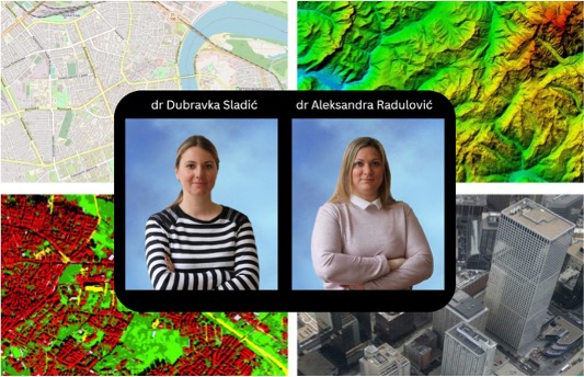
University of Novi Sad – NSGeoLab
Course Concept: EO data management and applications in sustainable urban development
Dubravka Sladić (Full Professor) and Aleksandra Radulović (Associate Professor) are teaching stuff at the Faculty of Technical Sciences, University of Novi Sad, specializing in Geoinformatics. Both hold Ph.D. degrees in Geoinformatics and have extensive experience in spatial data management, geospatial analysis, and the application of advanced GIS technologies. They possess comprehensive expertise in all areas of Geoinformatics, including Geographic Information Systems (GIS), Remote Sensing and Earth Observation. They teach courses at all levels of study—undergraduate, master, and doctoral—and are authors of a significant number of papers published in high-impact journals. They have participated in numerous scientific and commercial projects related to Geoinformatics, including Erasmus+ initiatives such as GeoWeb, BestSDI and GeoBIZ, where they have gained significant experience in curriculum development and modernization of geoinformation education. This combination of project involvement, academic authorship, and applied work demonstrates strong technological expertise and the ability to align educational and business practices with industry and international standards.
Dr. Miljan Šunjević
Course Concept: Advanced Environmental and Urban Analyses using Copernicus
Dr. Šunjević brings a unique blend of architectural and environmental engineering, expertise that makes him exceptionally well-suited to deliver specialized training on the UDENE Exploration Tool. His professional background is rooted in both urban design and environmental impact assessment, enabling him to connect technical EO analysis directly to real-world urban and environmental applications. As a Scientific Associate at the University of Novi Sad, Faculty of Technical Sciences, Department of Environmental Engineering and Occupational Health & Safety, he has conducted and published researches that integrate spatial data analysis, urban morphology, and pollution modelling.
FeedIN GREEN (Startup – Tunisia)
Course Concept: Vertical Urban Farming Enhanced by EO & AI
Our startup, founded in 2023, has been fully dedicated to developing vertical urban agriculture solutions enhanced by Earth Observation and Artificial Intelligence. We have successfully designed and prototyped controlled-environment farming systems that optimize resource use and crop productivity. The team has hands-on experience in deploying sensors, IoT devices, and AI algorithms in real-world urban farming environments.

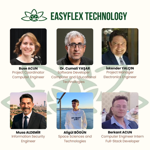
EasyFlex (SME – Türkiye)
Business Concept: Urban Heat Island mitigation and water-efficient agriculture
At Easyflex, we are building an R&D ecosystem that spans from local to global scales to make agriculture data-driven and sustainable. Our TÜBİTAK 1507-funded project, “Machine Learning-Based Smart System Solutions for Soilless Agriculture,” delivered local and innovative solutions in greenhouse automation. We expanded this expertise to Europe with the Horizon Europe program’s RURACTIVE project, contributing to the digital transformation of rural areas. Now, with our Udene-supported FlexiUdene project, we are integrating Copernicus satellite data with IoT-based ground sensors to develop climate-resilient, resource-efficient smart agricultural systems. With our AI-powered analytics, we aim to achieve up to 90% water savings and an 80% yield increase. Our goal is to pioneer the digital transformation of agriculture with accessible technologies for everyone, from small family farms to large-scale enterprises.
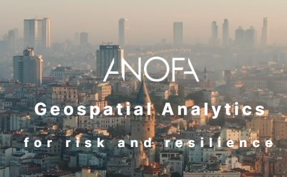
Anofa (SME – Türkiye)
Business Concept: Urban growth scenarios anticipating disaster resilience
Anofa provides geospatial analytics and urban resilience services for municipalities, development agencies, and industry, with expertise in disaster risk modelling and urban planning. Our service portfolio supports decision-making through a combination of spatial modelling, EO data integration, and consultancy
GILAB (SME – Serbia)
Business Concept: EO-Driven Urban Heat Intelligence
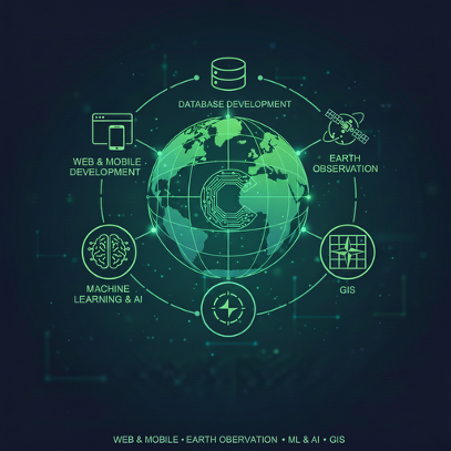
GILAB specializes in Geoinformatics and GIS, delivering customized 2D, 3D, and spatio-temporal (3D+) solutions across all data formats using advanced geospatial technologies. We provide full-cycle web and mobile application development, covering back-end, front-end, and database engineering to deliver complete, ready-to-use products. Through Remote Sensing, we leverage optical and radar imagery—primarily Copernicus open data—to support cost-effective Earth monitoring and mapping solutions. Our Web Cartography services include building complete geoportals with interactive maps, advanced visualization tools, and full web-GIS functionality. In Spatial Data Science, we apply machine learning and geostatistics to analyze complex spatio-temporal datasets and develop robust predictive models. GILAB also offers consulting services in GIS, Earth Observation, INSPIRE, geospatial modeling, and related domains, complemented by reliable DevOps support to ensure scalable and secure system deployment.
Lilly021 (Startup – Serbia)
Business Concept: Test modifications to the city’s traffic network
Lilly 021 d.o.o. is a dynamic Serbian software company headquartered in Novi Sad, specializing in delivering tailored digital solutions for businesses of all sizes. They focus on smart, attractive software engineering—from mobile and web development to ERP, e-commerce, blockchain and AI integrations—aimed at enabling client business growth through impactful technology.
DRILLSERV (Startup – Tunisia)
Business Concept: Urban Forest Corridors for carbon sequestration
DrillSERV is a technology-driven startup specialized in Earth observation and the sustainable management of natural resources.
We combine geospatial intelligence, hydrogeological expertise, and smart monitoring systems to support water, environmental, and agricultural stewardship
Institute of Industrial Management USfax
Business Concept: Copernicus-enabled service that predicts PV soiling risk
The Data Engineering and Semantics Research Unit is a research centre within the Faculty of Sciences of the University of Sfax (USfax), established in 2021. The Unit brings together scholars in data engineering, semantic technologies, artificial intelligence and big data, aiming to develop intelligent, knowledge-driven systems that transform complex data into actionable knowledge. Its mission encompasses coordinating and disseminating research output on intelligent systems driven by knowledge resources, automating tasks across diverse application domains. The Unit maintains an active research ecosystem, including doctoral defences in areas such as social data analytics, fraud detection and IoT-era business-process deployment under hybrid federated (fog-cloud) environments. Among its flagship projects are the standardisation of the Tunisian dialect (linguistic reference bibliography, orthography and morphology) and its involvement in WikiResearch-type initiatives. Through this active research and training framework, DESLab serves as a regional hub for innovation, knowledge transfer and advanced research in data engineering and semantics